- Old House Farm
Bailes Lane
- (also known as "Tickners")
The name of "Tickner", in its variant phonetic forms, has
been around for centuries and in its modern form is perpetuated in Normandy
on Ordnance Survey maps as "Tickners Bridge" (Grid reference
SU936518 refers), as discussed in the article on Tickners
Bridge. Strangely, there is no historical family record of a Tickner
family in Normandy. There is knowledge of a relatively modern family of
that name having lived at Perry Hill Worplesdon. The supposition (in the
absence of documentary evidence to prove otherwise), is that the name Tickner
and its association with Normandy is no more than a locality name, albeit
that until 1962 Tickners Bridge remained an important parish boundary marker
between Worplesdon and Normandy.
The name is possibly of Saxon or old English origin being derived phonetically
from the word "Titnes" meaning a division of 'the ways' that
is to say, at a Y junction of what we would recognise in today's modern
world as roads. In yesteryear 'the ways' were no more than greenways,
drover roads and paths
The 1844 Normandy Tithe map, for example, shows clearly the Y division
of Tickners Bridge Road (now the Guildford Road - the A323) at Anchor Close,
the site of the former Anchor Public House (origin about 1613) but regrettably
demolished in 2000. The pub was the hub of early Normandy. At this point,
the map shows the Guildford Road from the direction of Ash split into two
ways. The A323 continues towards Willey Green corner as at present, but
the "minor way" peels-off to the right and recently has been
named Wells Lane. In 1844 Wells Lane would have been little more than
a cart track giving access to "Pritchells" (a mid 15th Century
cottage) and "Mintners" (an equally old cottage) now named "Old
Cottage". The lane remains un-made and is probably in no better condition
now than it was in 1844 when it gave access southwards to Flexford and
Wanborough.
There were a number of named fields around that junction, two of which
were Tickners Field and Tickners Moor. Moreover, the Cleygate Manorial
Records also revealed references to ancient named fields in that area.
They had a remarkable phonetic similarity to that Saxon or old English
word "Titnes". The earliest mention in 1485 was with reference
to Tittemershe and Liteltitmershe leased to Robert Raunce. There follows
Long Tytnes and Little Titnes let in 1548 by Edward IV to Gregory Levett,
Tytnes Mead (1580) and Long Tiknors (1687).
In 1546 we read of a tenement and land in Worplesdon called 'Pursses'.
On the death of William Purse the property descended to his son John.
The title of this land descended through the Purse family until 1682 when
it was described as "a freehold messuage and 25 acres of land called
Tickners', held by George Collins. Thus we have from our records the earliest
mention of the name Tickners. Ownership descends in the main through the
Bicknell family until the Collins family emerge once again in the late
1800s
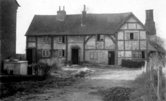
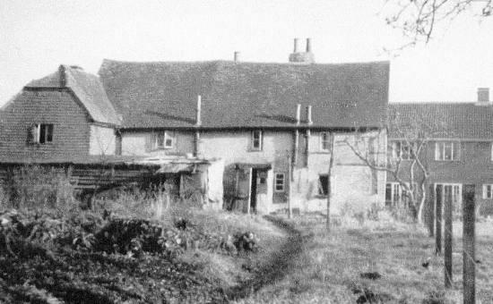
It was in the mid 1800s that the farmhouse (by now familiarly known
as 'Tickners'), was converted into four dwellings and the outbuildings,
fronting Bailes Lane, were converted into two dwellings. Later in about
1870, two houses were built close-by on the farm land and the eight cottages
were collectively named New Cut Cottages. In 1965, the outbuildings fronting
Bailes Lane were demolished and replaced by six new houses. The old farmhouse
remained occupied until the last tenant was re-housed at Walden Cottages
in 1957, following which the old farmhouse was demolished. The two houses
built in 1870 remain and until quite recently were known as 1 & 2 New
Cut Cottages.

- Oldhouse Farm (Tickners), Bailes Lane c1957 - Front View
This poor quality photograph of the farmhouse, taken just before its
demolition in 1957, gives insufficient information to be sure of its age.
However, the arching braces of the main range suggested a medieval date
of about 1550 (in building terms), but the eaves being relatively high,
indicated that a build date towards the end of that period was more probable.
Certainly the originality of the building looked the "pre-chimney"
period. The arrangement of the main bay posts was deemed to be unusual,
as was the half-bay at the left-hand end. The gabled form would normally
be post medieval and it may be that this end was added, and the roof form
changed. The right-hand end appears to be later, probably 17th Century
since it has small panel framing. Following its demolition it was noted
that the foundation for the base brickwork was composed of local stone
and some irregular stone and flint.

- Oldhouse Farm (Tickners), Bailes Lane c1957 - Rear View
Peter Blakiston
|